Title image is the International Space Station passing in front of an unusually "spotless sun", the sun with no sunspots, in July 2019. Image credit: NASA
It is possible to begin to orbit the Earth from around 80-100km, the approximate boundary of space. But, this would only be for a really short time due to the drag force from the residual atmosphere. This force has an effect on all spacecraft up to at least 500km altitude, but on occasions to over 1000km altitude.
Most spacecraft will fly at altitudes from around 300km upwards, and all orbits below 2000km altitude are termed low-Earth Orbits, or LEO. In this region spacecraft will complete a revolution of Earth in about 90-120 minutes. And, the duration, or period of an orbit increases as altitude increases.
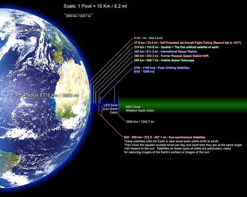
Beyond LEO is the region known as Medium Earth Orbit, where we find the various Global Navigation Satellite Systems, or GNSS constellations, such as the United States' Global Positioning System, GPS. Typically, spacecraft like this will complete a revolution of the Earth in around 12 hours.
As we continue to get further from the Earth we reach geostationary Orbits, GEO, at an altitude of approximately 35871km, where spacecraft complete a revolution of Earth, directly above the equator, in one day. This means a geostationary spacecraft appears stationary in the sky as it is rotating at the same speed as the Earth.
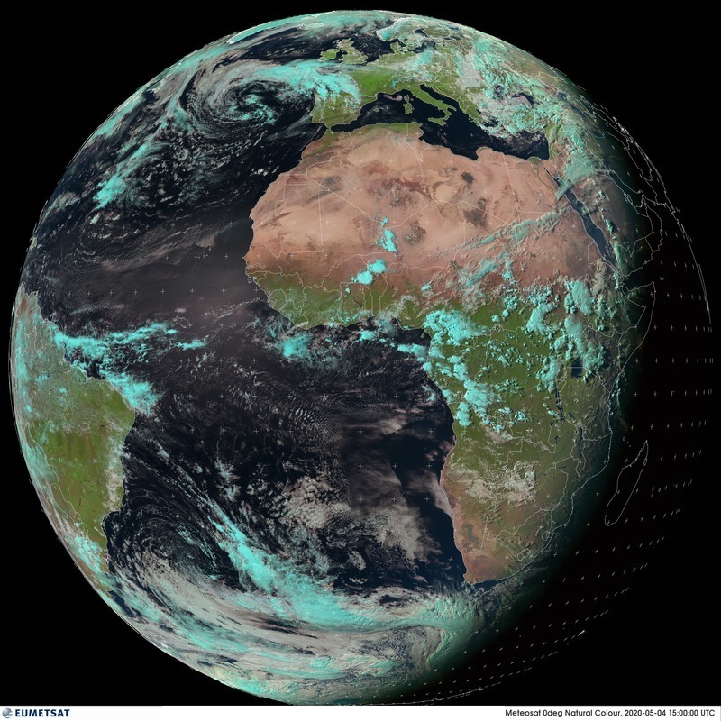
These GEO spacecraft are really useful for providing regular hemispherical images of the Earth for use in weather forecasting, and for providing communication services, everything from live and rolling 24-hrs global news through to coverage of major sport events.
But, they do suffer from a horizontal foreshortening effect at higher latitudes, where detail in images is lost due to the curve of the Earth away from the spacecraft. This can be an issue for weather satellites for anything north of Glasgow or Moscow. And, again due to the curve of the Earth, if you are north of Svalbard, at over 81 degrees latitude GEO satellites are below the southern horizon and of no use.
Curiously, the 1976 Bogotá Declaration was an attempt by several equatorial nations to claim sovereignty over geostationary orbits as a natural resource of the country over which they exist. This would have meant that space began at some point beyond GEO. These claims have been largely abandoned.

The Moon is found at approximately 10 times the distance to GEO, or over 60 times the radius of the Earth. Beyond the moon, there are other useful orbits. To understand these, we must now consider the effect of the Earth’s and of the Sun’s gravity on our spacecraft; the so-called three-body problem. Because there are three bodies, our spacecraft, the Earth, and the Sun, and due to the challenge, or problem, of predicting how the gravitational forces interact, and consequently, predicting future motion, which is a function of the mass of each and the distance between each.
As a spacecraft moves away from the Earth, the gravity of the Sun begins to increasingly influence its motion. Far enough away from the Earth, and the influence of the Earth’s gravity is lost and the spacecraft orbits the Sun just as Earth does. It follows that at some point the influence of both the Earth's and the Sun’s gravity must be equal. This is termed a Lagrange Point, and there are five of them. The first three were discovered by Leonhard Euler, and the remaining two by Joseph-Louis Lagrange.
The first Lagrange Point, L1, is located on a line connecting the Earth and the Sun, about 1.5 million kilometres from the Earth, that’s about 1% of the distance to the Sun, or equivalent to over 37 times around the Earth. The second Lagrange Point, L2, is again located on the Sun-Earth line and at a similar distance from Earth, but away from the Sun.
These two Lagrange Points provide valuable vantage points. From L1 we can observe the Sun without the Earth getting in the way, and we can look back at the Earth in continuous daylight, and from L2 we can observe the universe without the Sun or the Earth getting in the way.
The Lagrange Points are only the edge of Earth’s local region in space. There is a lot more space beyond the Lagrange Points, and counting in kilometres becomes a challenge so we tend to use astronomical units, au, where 1 au is the Earth’s distance to the Sun, about 150 million kilometres. Humanity has sent spacecraft to every planet in the solar system, and we’ve even sent spacecraft beyond our solar system, with Voyager-1 the first to leave in August 2012 when it was at around 121 au from the Sun. Voyager-1 continues to move at around 3.6 au per year away from the Sun, and is destined to eternally wander the Milky Way, very occasionally passing nearby to a star every few tens or hundreds of thousands of years.
Electronic & Electrical Engineering
Royal College Building
204 George St.
Glasgow G1 1XW